

.png)

What's our vector, Victor? AP Photo / Library of Congress
Every space mission depends on overcoming two basic challenges - 1) spacecraft must reach the desired destination and 2) they must survive long enough to complete their tasks. This may be painfully obvious or even taken for granted these days, but that doesn’t make it easy. Many spacecraft don't have any means of propulsion, so they have little choice but to stay in the orbit where their rockets left them. They just need to survive the dangers of outer space: utter vacuum, constant radiation bombardment, extreme temperatures, and a chance of collision with any of the millions of pieces of space debris. No sweat, right?
Let’s just focus on the orbit part for now. In a recent blog post we wrote about the importance of planning communications with a satellite, and we mention that doing so requires knowledge of where it will be in the future. This idea of computing a spacecraft’s upcoming location is essential to every mission. Us space nerds like to refer to this process as orbit propagation. But before we can determine where a satellite is going, we need to know where it’s been. This is done in a process called orbit determination (we love our jargon).
What is Orbit Determination?
The process has its roots in the 17th century, when Johannes Kepler started to describe a satellite’s orbit (for him it was planets orbiting the sun) using 6 mathematical elements. These quickly became known simply as the orbital elements - they describe the shape, size, and orientation of an orbit, as well as the position of a satellite in the orbit at a given time (epoch). Kepler’s methods were advanced over time by many contributors, but what is used today is largely an evolution of those same concepts Kepler laid out. In fact, one of the most common formats used to communicate an object’s orbit, the two-line element set (TLE), includes several of the original six orbital elements – more on this later.
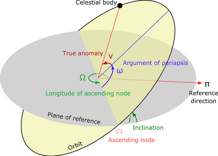
Keplerian orbital elements
So how are the orbital elements determined? It starts by collecting observations, and until the past several decades, it was done almost exclusively by tracking a spacecraft with an antenna and receiving radio signals. Simply put, the angles that define the antenna’s pointing direction, called azimuth and elevation, provide a relative position vector, while processing the signals received can provide the range and range-rate. Today the industry utilizes many different methods and types of observations to track an artificial satellite’s orbit, some of which require specific equipment on-board the spacecraft:
- Active radar systems: large radar arrays that actively transmit signals and receive the energy reflected off space-borne objects to compute their position and velocity. There are several government networks that do this (see NASA’s Deep Space Network and the U.S. Space Force’s Space Surveillance Network); recently commercial services can provide specific capabilities to the private sector.
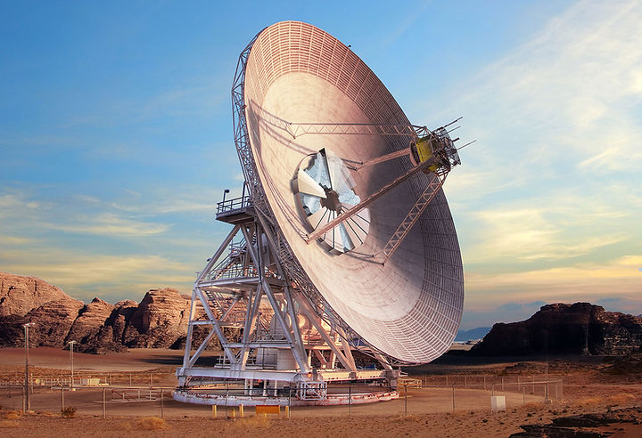
NASA's Deep Space Network Ground Antenna
- Global navigation satellite system (GNSS): space-based broadcast satellites that provide position, navigation, and timing (PNT) signals. The most well-known example of this would be the U.S. government owned and operated Global Positioning System (GPS), which was originally intended for users on Earth, but now is used by satellites that are equipped to receive the broadcasts.
- Doppler Orbitography and Radiopositioning Integrated by Satellite (DORIS): similar in principle to GNSS by providing PNT signals, the DORIS transmitters are located on Earth’s surface and broadcast into space specifically for satellite consumption. The DORIS system is developed and operated by the French Space Agency.
- Satellite laser ranging (SLR): a more accurate version of the typical tracking and ranging antenna systems but uses light to measure position and velocity to a high degree of accuracy.
Observations are merely the beginning though - to arrive at an orbit definition we need to do some mathematical acrobatics involving vectors, conic sections, and clever algorithms like that of Lambert’s problem and Gauss' method. Taking the relative position vector of an infinitesimally small mass… just kidding, we’ll skip the math lesson today.
Engineers and operators in the industry don’t need to be experts on the math - there are numerous tools and services that assist with orbit determination. A modern operations system like Quindar will automatically process incoming observational data - whether it be from GPS-derived state vectors, ground station radiometric tracking measurements, or 3rd party active radar data - to continuously provide the latest orbit determination. Better yet, we will soon undergo a data fusion effort to combine all available inputs to provide the most accurate result available.
At the end of the orbit determination process we often need to communicate and store the outcome. This brings us back to the TLE mentioned above. The TLE format has seen decades of successful use (they were designed as a format for punch cards) and are still very common in the industry. The 18th Space Force Squadron disseminates the orbits of all the objects they track using TLEs to this day. That said, there is more to be desired. The details of how an orbit is communicated effectively is a topic that deserves its own post (maybe we’ll do one!), but in general the TLE conveys only averages of elements that are actually oscillating terms. Now that network bandwidth and storage are of lesser concern, the industry is moving toward larger information sets with more precise components.
What is Orbit Propagation?
Now that you’re an expert in orbit determination, let’s look at propagating an orbit. The output of the OD process above provides all the information needed to compute where a satellite is at a given time. This can even be in the past (sometimes called back-propagation) - which is also very useful in spacecraft operations and mission analysis. But generally, by orbit propagation we mean forward in time to predict where a spacecraft will soon be.
Kepler provided an analytical solution to the propagation problem as Kepler’s laws of planetary motion that were published in 1609. It provides a very simple method to compute the relative motion of two bodies in space and can be used directly to estimate where an object will be at a given time using the orbital elements. However, Kepler was working with a limited understanding of the physical world (he did all this before Newton even explained gravity!). His model was intended only to describe the motion of our solar system. It is simply not accurate enough for modern applications in satellite operations.
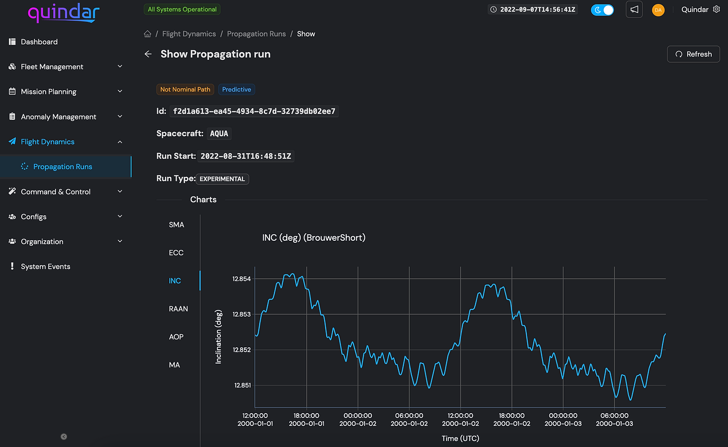
Example of a propagation run in the Quindar platform
Methods used today consider additional physical phenomena to improve accuracy of the prediction and are tailor-made for spacecraft. For example, we know now that near-Earth satellites are affected by the moon’s gravitational field and atmospheric drag. These small external forces, or perturbations, are hard to forecast and contribute to inaccuracies of a propagated orbit. The current standard in satellite engineering is to use the applicable simplified perturbation model that take these forces into account. Commonly used is SGP4, the Simplified General Perturbations propagator. This algorithm utilizes the TLE format as input and generates a solution that is adequate for most mission planning activities. To get technical, the solution typically has an error that increases by about 3 km per day of forward propagation. That increasing error is the main reason that orbit propagation is a constant task: take measurements, determine the orbit, propagate the future position. Repeat.
We'd love to explain how to plan the optimal maneuver to reach your target orbit, but we'll have to save that for another blog.
Summary
The basic objectives of determining a satellites past, present, and future position are:
- 🪃 Orbit Determination: Where was the satellite?
- 💫 Orbit Propagation: Where is it going?
Quindar provides this as a service for your satellite constellation. We track each satellite's position, determine where it is going, and reserve antenna time with our partners so you can maintain command and control.
This post was relatively deep for your average blog, yet it paints only a fuzzy picture of everything involved to conduct these tasks correctly and consistently. At Quindar, these capabilities are standard. It’s our belief that the modern operator should not need to concern themselves with maintaining some of the most fundamental tasks of spacecraft operations. Space missions today are always adding on complexities, layer by layer, and the environment in space is getting more crowded every day. Operators have more to worry about and should not spend their energy recreating what has been done by countless astronomers and engineers in the past.
Happy orbiting!

Stay ahead of the curve
Subscribe to our blog to get updates straight to your inbox.
%20(3).png)
.png)
.png)


%20(1).png)

.png)


